DATA has revealed a colossal mineral-rich part of Northern Australia now spans an area bigger than Tasmania.
New figures from the Australian Government show seismic data from the South Nicholson Basin shows the area covers over 91,000 square kilometres.
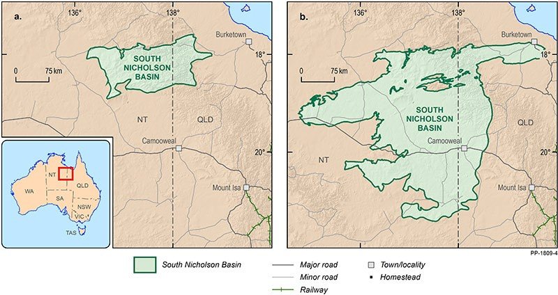
The renewed analysis of the region indicates the potentially mineral-laden area overlapping the NT-Queensland border is three times larger than previously known.
Ongoing surveys of the South Nicholson Basin were led by Geoscience Australia as part of the Government’s $100-million Exploring for the Future (EFTF) program.
The re-evaluated data is another piece of the puzzle in learning more about the location and scale of the region’s potential oil, gas and mineral resources.
Minister for Resources and Northern Australia Matt Canavan released the information on March 20 to coincide with the Annual Geoscience Exploration Seminar (AGES) in Alice Springs.
He described the findings as a result of one of the largest studies of its kind in Australia, with more than 1100 kilometres of seismic reflection data collected.
“Together with previously released gravity data, these new data dramatically increase our geological understanding of this diverse region,” he said.
Mr Canavan hailed the data as outlining “great potential for mineralisation” but admitted it was too soon to say just how much resources the basin holds.
“Geologically, it lies at a critical junction in northern Australia — between the world-class mineral-endowed regions of Mount Isa and Tennant Creek,” he said.
“The neighbouring McArthur Basin contains both oil and gas, and the newly enlarged area of the South Nicholson Basin may be similarly prospective.”
Minister Canavan said a key to Australia remaining a world leader in mining and resources investment was to keep gathering new and more detailed geological data.
“We know detailed geological data collected in the South Nicholson Basin region is vital to stimulating more exploration activity across northern Australia,” he said.
“More datasets will be released later this year, followed by targeted stratigraphic drilling in 2019.
“EFTF represents a new frontier for resource discovery in northern Australia, providing insight for exploration companies to identify new prospects for petroleum, mineral and groundwater resources in this region.”
The study is one of the largest of its kind ever undertaken in Australia – consisting of five seismic lines with more than 1,100 km of seismic reflection data collected across the Northern Territory and Queensland border.
Based on this new information, updated geology maps reveal the basin is approximately three times larger, with the new outline increasing the area of the basin from 37,921 to 91,368 square kilometres. Together with previously released gravity data, this dramatically increases our geological understanding of this poorly understood region.
Following this data release, more datasets and comprehensive analysis will be released later in the year, followed by targeted stratigraphic drilling in 2019.
The South Nicholson data acquisition is one of 17 projects underway across northern Australia and South Australia as part of the $100.5 million EFTF program led by Geoscience Australia. The seismic reflection survey was undertaken in partnership with the Northern Territory Geological Survey, the Geological Survey of Queensland and AuScope.
Resources and Energy Group AREEA welcomes more investment into gaining a better understanding of our country’s resources, which can in turn be developed to create jobs and economic growth.
“Acquiring more detailed geological data is a positive step toward identifying the mines of the future,” AREEA Head of Policy and Public Affairs, Tom Reid said.
“The information derived from these surveys is vital in understanding the potential for developing future resources and driving more exploration.
“At a time when levels of exploration are in decline, AREEA welcomes continued investment in developing data to better understand the opportunities we are blessed with in our resource-rich country.”